Camp
Schwab and Okinawa, Japan is located on the Eurasian Plate and on west side
of the Philippine Plate and on the border of the a convergent plate
boundary. The geographic location of the island of Okinawa cause many
geographic and geologic phenomena to occur. The island being
located close to a tectonic plate boundary cause formation of land, as well as,
earthquakes and being at about 27°N Latitude, the island is susceptible to
typhoons. The island's location is directly in the "line of
fire" for typhoons, which will cause mass wasting, and weathering to the
island over time. I will hypothesis what the islands physical geography might look like in the next 1,000, 10,000, and 1,000,000 years in the future.
 In
1,000 years, Okinawa will look relatively the same as it does today. The typhoons
and heavy monsoons that occur on Okinawa will most likely cause continuous mass
wasting of the loose soil and the surface of the island. The island receiving
an average of 87.5 inches of rain per year according to www.naha.climatemps.com, after 1000 years that rain equals to 87500 inches of
rain. So, after 1000 years, the island may not have the top soil it has today
and more rock may be exposed. Weathering such as Basal Weathering will
decay the rock cliff on the sides of the island, creating notches at the bottom
and could cause cliffs to succeed into the ocean, decreasing the amount of land
mass on the island. The cliffs shown above-left, provided by http://commons.wikimedia.org/wiki/File:Okinawa_cliff.jpg,
demonstrate the Basal Weathering as well as Cavernous Weathering that will
weaken the rock over time by causing alveoli and tafoni due to salt
weathering.
In
1,000 years, Okinawa will look relatively the same as it does today. The typhoons
and heavy monsoons that occur on Okinawa will most likely cause continuous mass
wasting of the loose soil and the surface of the island. The island receiving
an average of 87.5 inches of rain per year according to www.naha.climatemps.com, after 1000 years that rain equals to 87500 inches of
rain. So, after 1000 years, the island may not have the top soil it has today
and more rock may be exposed. Weathering such as Basal Weathering will
decay the rock cliff on the sides of the island, creating notches at the bottom
and could cause cliffs to succeed into the ocean, decreasing the amount of land
mass on the island. The cliffs shown above-left, provided by http://commons.wikimedia.org/wiki/File:Okinawa_cliff.jpg,
demonstrate the Basal Weathering as well as Cavernous Weathering that will
weaken the rock over time by causing alveoli and tafoni due to salt
weathering. 
In 10,000 years, Okinawa, Japan the rock
that will portray due to the mass wasting of the previous years will continue
to decay and the island may become flatter. With continued rainfall over 10,000
years, the top soil will wash away leaving only rock exposed. With the
continued rainfall and the island consisting of Basalt and Coral, both of which,
are susceptible to weathering due to high levels of rain. The picture above shows
rock protruding from the surface due to weathering and removal of the top soil,
provided by http://www.japan-guide.com/e/e7113.html.
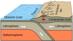 In 1,000,000 years, Okinawa Japan may
be much larger than it is today. The island is located just west of a larger
trench on the sea surface floor. The trench is caused by a convergence tectonic
plate boundary between the Philippine Plate and the Eurasian plate, where the
Philippine Plate is subducting under the Eurasian Plate. The convergence
boundary could cause the melting of the oceanic plate (the Philippine Plate)
under the continental plate (the Eurasian Plate) and may cause more islands to
arise around the island or even build onto the island. Another phenomenon that could occur is that the island of Okinawa could move further into the Philippine Sea and end up being located even further from the Asian Continent, this could happen because the Eurasian Plate is moving southeast. This classic textbook
picture provided by http://en.wikipedia.org/wiki/File:Active_Margin.svg.demonstrates
the process of how island can be formed.
In 1,000,000 years, Okinawa Japan may
be much larger than it is today. The island is located just west of a larger
trench on the sea surface floor. The trench is caused by a convergence tectonic
plate boundary between the Philippine Plate and the Eurasian plate, where the
Philippine Plate is subducting under the Eurasian Plate. The convergence
boundary could cause the melting of the oceanic plate (the Philippine Plate)
under the continental plate (the Eurasian Plate) and may cause more islands to
arise around the island or even build onto the island. Another phenomenon that could occur is that the island of Okinawa could move further into the Philippine Sea and end up being located even further from the Asian Continent, this could happen because the Eurasian Plate is moving southeast. This classic textbook
picture provided by http://en.wikipedia.org/wiki/File:Active_Margin.svg.demonstrates
the process of how island can be formed.


